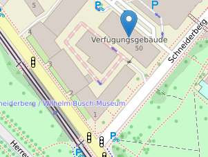
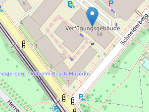
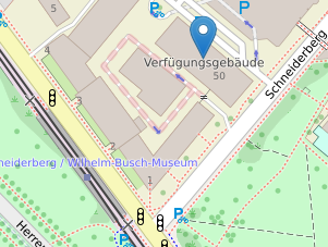
Address
Leibniz University Hannover
Institute of Geodesy
Schneiderberg 50
30167 Hannover
Germany


Office
Getting here
-
By Public Transit
Please consult the Deutsche Bahn DB AG to plan your trip to Hannover Central Station (Hauptbahnhof or Hbf).
From Hauptbahnhof take tram lines
- 3, 7 (destination Wettbergen) and
- 9 ( destination Empelde) or
- 1 (Sarstedt),
- 2 (Rethen) or
- 8 (Messe)
to "Kröpcke" (1 stop). Transfer to tram line
- 4 (Garbsen) or
- 5 (Stöcken)
Get off at "Schneiderberg/Wilhelm-Busch-Museum" (4 stops). A short walk up Schneiderberg takes you to the Institute of Geodesy which is located in the second building to your left on the 4th floor.
A GVH transit plan of the Hannover tram lines can be found here.
-
By Car
Arriving via motorway A2, Dortmund – Berlin
- Exit at "Hannover Herrenhausen" and take Bundesstrasse 6 in the direction of Hannover.
- If you are arriving via the Messeschnellweg take exit "Herrenhäuser Gärten"and follow the signs to the university (Universität Hannover). Exit to the right onto Herrenhäuser Allee. At the Shell petrol station turn right onto Nienburger Strasse.
- At the second traffic signal turn left onto Schneiderberg. The institute is located in the second building to your left on the 4th floor. Ample parking is available at the parking garage on the North side of the building.
Arriving via motorway A7, Kassel – Hamburg
- Exit at "Hannover Süd (Messegelände)" taking Bundesstrasse 6 in the direction of Hannover.
- Drive past the Hannover fairgrounds, then, at the Aral petrol station on the right, take the exit to Bundesstrasse 65 in the direction of Minden, Hameln. At the roundabout turn right, at the two following roundabouts go straight.
- You now enter the Messeschnellweg again. At the first traffic light turn right onto Bremer Damm. At the end of the Schnellstrasse at Königsworther Platz turn to the left, the left again onto Nienburger Strasse. At the first set of lights turn right onto Schneiderberg. The institute is located in the second building to your left on the 4th floor. Ample parking is available at the parking garage on the North side of the building.
-
By Plane
At the Airport Langenhagen take the suburban train S1 (direction Paderborn Hbf) and get off at Hannover central station (Hauptbahnhof or Hbf).
From Hauptbahnhof take tram lines
- 3, 7 (destination Wettbergen) and
- 9 ( destination Empelde) or
- 1 (Sarstedt),
- 2 (Rethen) or
- 8 (Messe)
to "Kröpcke" (1 stop). Transfer to tram line
- 4 (Garbsen) or
- 5 (Stöcken)
Get off at "Schneiderberg/Wilhelm-Busch-Museum" (4 stops). A short walk up Schneiderberg takes you to the Institute of Geodesy which is located in the second building to your left on the 4th floor.
A GVH transit plan of the Hannover tram lines can be found here.


